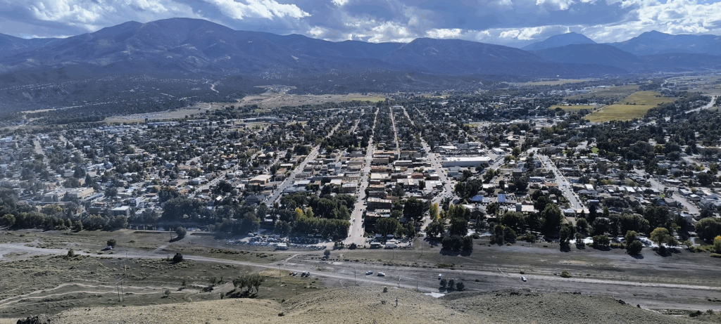
2025 brought a seismic shift in that Jon retired in May. With all that additional time on his hands, travel naturally percolated to the top of the To Do list. In all of Jon’s domestic travels, only one state had not been visited. He did consider making it happen once, but the four hour (each way) drive from Sioux Falls South Dakota to step foot into North Dakota quashed that idea.
At the risk of stating the obvious, a multi-week trip through much of the continental US involves a lot of preparations. Examples included: Lining up dates with family and friends (months in advance of our trip), researching interesting places along our route as well as buying a new Rand McNally Road Atlas (can’t always count on mobile network access out west). Technology advanced substantially from Jon’s last cross country trip undertaken in 1981. A notable example was installing the NPS app on my phone (and checking it daily).
Enjoy our adventures by viewing the daily blogs below. For those who don’t follow me on Instagram, I started each day’s entry below with content from that day’s Instagram post. Additionally, you can view images in Plains, Mountains and Canyons depicting our trip.
September 3, 2025 – Drive from RVA to Chicagoland
We started out around 7:00 AM to get to Arlington Heights Illinois as early as possible. Even gaining an hour, we pulled into the hotel parking lot after 7:30 PM local. After all, it was a 13 hour 827 mile drive. Needless to say I didn’t enjoy the end of Gary Indiana or Chicago’s rush hour traffic in the rain.
Dinner was at the Branch River Grill and was more upscale than I expected for a Doubletree Hotel. Fortuitously Wednesday night was burger night and the wallet wasn’t seriously impacted. I was pleased the proximity to O’Hare didn’t interrupt our sleep with plane takeoffs (no doubt attributable to prevailing winds that night).
September 4, 2025 – Drive from Arlington Heights to Fargo
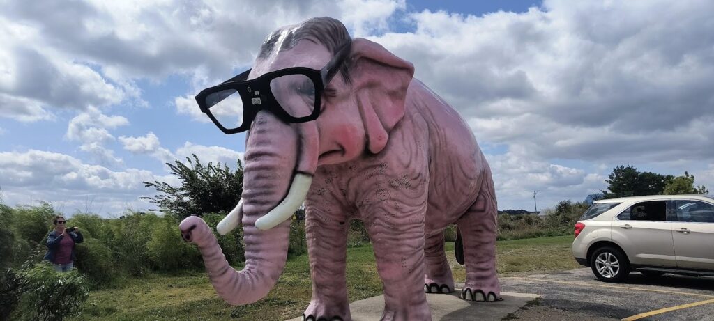
Yesterday was a 13 hour straight through drive to Chicagoland. At only 9 hours to Fargo today we have time for diversions such as Madison’s world famous Pink Elephant.
Up early for breakfast at the Golden Bunch with Cathy’s half-sister Peggy. Though just under a mile from the hotel, we decided driving there made more sense during Chicagoland rush hour on busy streets. We got on the road by 9:00 AM with expectations of reaching Fargo by 6:00 PM local time.
After gassing up at the Rockford Costco (one of many such fillups this trip), we began our second long day in the car. Naively thinking today would be a shorter drive (slightly at 622 miles), we stopped at the Pink Elephant just north of Madison Wisconsin. Pinky has been at this gas station since the mid-late 1960’s. Thanks to non-stop roadwork (triggering lane closures and reduced speed) and epic rush hour traffic in the Twin Cities, we didn’t arrive in Fargo until after 8:00 P.M.
The Fargo hotel night clerk graciously put us in a huge suite. When she learned the reason for our trip was for me to get to my last state, she encouraged us to go to the Fargo Visitor Center. Apparently they recognize accomplishments like this with a t-shirt, a certificate and a photograph.
At 49 degrees, I appreciated not camping like the younger Jon might have done.
September 5, 2025 – Drive to Theodore Roosevelt National Park
I woke up this morning in my 50th state. Today’s adventures include time with the rough riders of North Dakota.
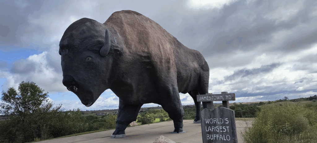
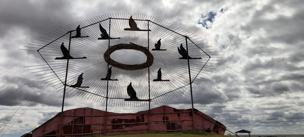
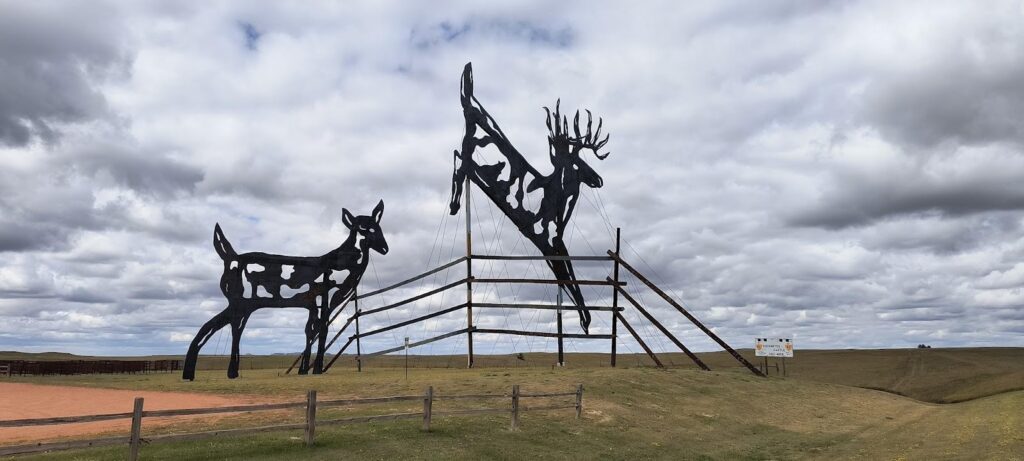
Our first day of National Parks. The first three images are of attractions before we reached the target park (Theodore Roosevelt). The world’s largest buffalo resides in Jamestown North Dakota. The middle two images are sculptures along the Enchanted Highway.

Our first stop was the Visitors Center for a t-shirt and picture recognizing having visited my 50th state. The drive there from the hotel was uneventful as Fargo basically has no rush hour. I noticed as soon as we got back on I-94 the highway closure barricades (to prevent driving those roads during blizzards). North Dakota’s nickname is the Peace Garden State which comes from the International Peace Garden, a park on the border of North Dakota and Manitoba, Canada. My personal favorite nickname is the Rough Rider state.
Shortly after exiting Fargo, we visited the World’s Biggest Buffalo (monument) in a really corny frontier village which had a very helpful (and personable) guide in the visitor center. On our drive across North Dakota we also crossed the Laurentian Continental Divide. This geographic feature determines if water flows into the Hudson Bay or to the Gulf of Mexico (at least in North Dakota). I knew we would be crossing the Continental Divide (twice actually), but wasn’t aware of the Laurentian Continental Divide until we passed a sign on I-94.
We experienced a bit of the Enchanted Highway. This artistic feature claims to be the World’s Largest Metal Sculptures. Time constraints limited us to visiting the two closest to I-94. My chief photographic complaint was suboptimal lighting coupled with the best view from just one direction. Even so, the scale and attention to detail was most impressive. One sculpture was so large that part of it had to be cut off to pass through the streets of a town. It was rewelded onsite at the installation.
Driving the length of North Dakota is not for the faint of heart. While the traffic wasn’t at all heavy and minimal road constructions reduced road delays, six hours of 80 MPH gets rather tedious. More frustrating was the endless stretches of 80 MPH still felt like we were crawling. Another downside was substantially reduced gas mileage. A hybrid CRV doesn’t get its best fuel economy at 80 MPH. About the only redeeming feature of this drive was North Dakota’s never ending highway views (some even were marked with signage).
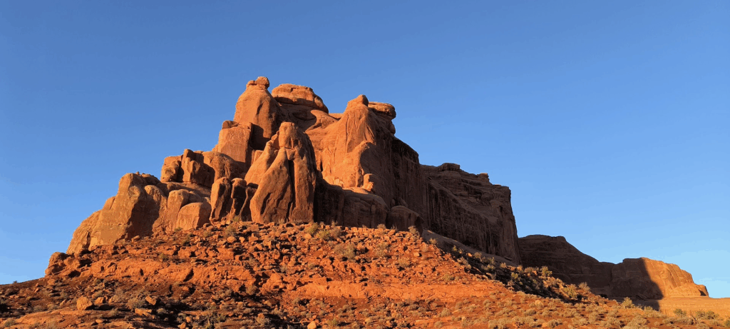
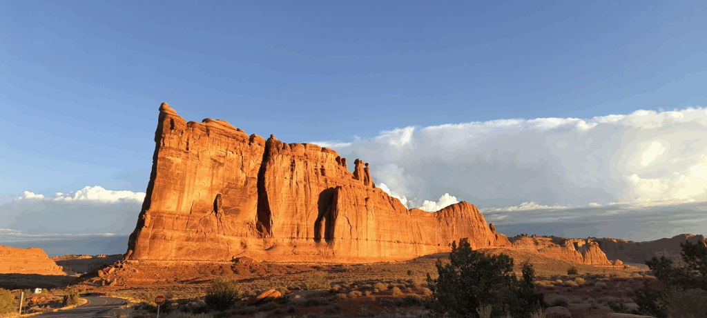
The scale of most western National Parks is such a short visit means you need to thoughtfully select your destinations. Theodore Roosevelt National Park has photogenic views in abundance. We only had three – four hours which restricted us to the South Unit. We observed some of the park’s animal life over several black tailed prairie dog towns, three groups of horses, and some avian species. Unfortunately we saw no buffalo, We observed buffalo pies on the roads and trails. The Painted Canyon Overlook, Skyline Vista and Boicort Trail illustrated Theodore Roosevelt National Park’s varied geology.
We had our dinner at Sakura for a hibachi meal. While not a Disney Shogun dinner, it satisfied our culinary needs. Being literally across the street from the hotel made the decision particularly easy.
September 6, 2025 – Dickenson North Dakota
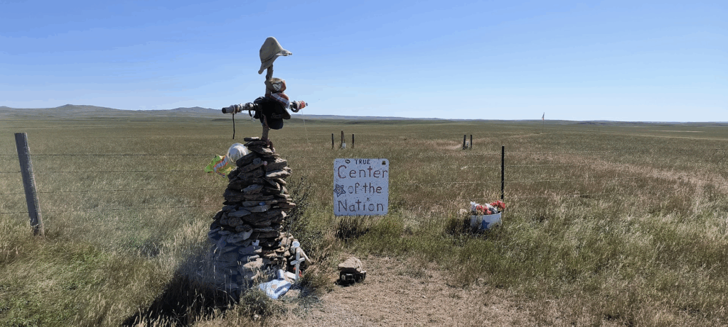
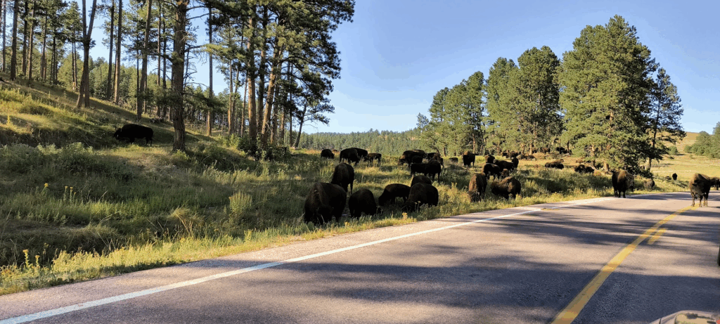
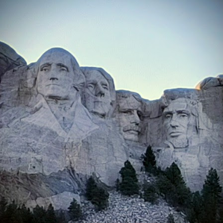
We had a busy day starting in Dickinson, North Dakota at 32 degrees. On the way to the hotel in Rapid City we encountered numerous wildlife, two geographic centers of the United States (don’t ask), a cavern spanning hundreds of miles without stalagmites (or stalactites), a bison jam along with four stone-faced guys. Tomorrow will be nice in that we stay in the same state the entire day and in the same room two nights in a row.
We got on the road before 8:00 to visit Wind Cave National Park and Mount Rushmore National Memorial. This is our first day of non-highway driving tooling along mostly empty two lane roads. As shown below, we avoided a small herd of deer.

During the drive I realized (and remembered) that trees grown around houses in this part of the country are for wind breaks. You can’t easily notice details like that while driving on a highway at 80 MPH. As another example, we just missed a pheasant flying low across the road. A highway speed avian impact would have no doubt caused serious windshield damage.
Realizing our route to Wind Cave went near the geographic center of the United States (image below), we learned we could easily add steps to Google Maps navigation (who knew?). It’s always nice to learn and act on something new. One thing that wasn’t new was to experience yet another Rand McNally “grey line” road. I’ve ended up on multiple such grey lines in my travels (often taken for “short cuts”). Common things such as pavement, lane marking and signage are almost never present on grey lines. The eight miles of unpaved road from US 85 up old US 85 (probably blazed by Lewis and Clark), to the Actual Center of the Geographic Center of the United States was no exception. We passed numerous ranches and several hunters (apparently bow season opened on September 1). The reason is the location is on private land and the owner didn’t (understandably) want public access to the location.
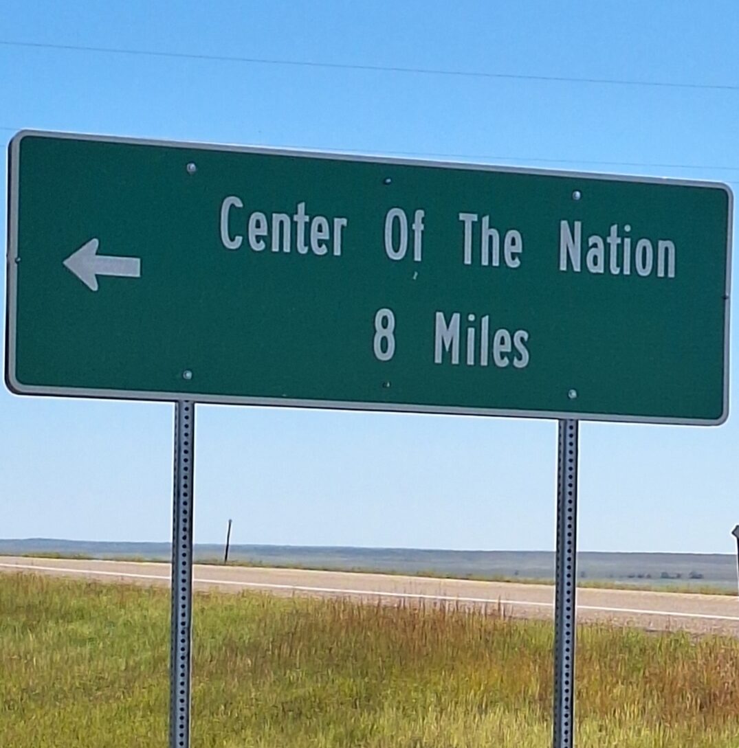
The folks in nearby Belle Fourche added the Geographic Center of the Nation Monument to their Visitor Center. In addition to being more photogenic (I am biased), the visitors center offered much needed plumbing. Those interested in other things could spend hours in Belle Fourche. We had a 2:30 PM scheduled tour in Wind Cave and needed every minute of the two remaining hours to arrive on time.
I didn’t pay attention to the graphic on the navigation route to Wind Cave National Park until two miles before the turn on to 7-11 road (no kidding). Clicking the graphic revealed the message “unpaved for 8.4 miles”. We got to experience two grey line roads today. This one offered more animals. Beside some cattle, we saw badgers, antelope and bison. Nevertheless, I was glad to pull into the Visitor Center parking lot.
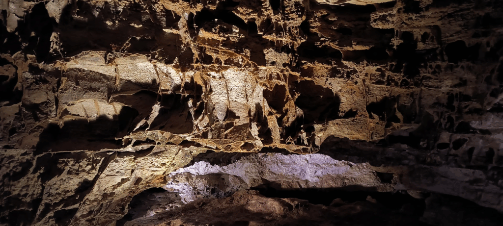
We took the Natural Entrance Tour. This tour starts near the Natural Entrance of Wind Cave which is the largest opening to the cave. Participants enter the cave through a man-made entrance and journey into the middle level of the cave. Wind Cave’s famous boxwork is abundant throughout this trip. Ranger Jacob was great. An unexpected addition to the tour was a presentation by Adrian, a local from a native tribe, at the original entrance. Adrian described how life was created. The Loota Emergence Story, passed down through many generations, describes how people were brought to the earth from an underground spirit lodge. I appreciated learning about the state of emergence. Wind Cave is one of the longest and most complex caves in the world containing over 150 miles of passages. It is considered a dry, breathing cave with no stalactites.
Right after leaving Wind Cave we drove a couple of miles to Beaver Creek Bridge. This historical bridge, built in 1929, was built to create access to nearby Custer State Park. Located between Wind Cave and Mount Rushmore, made it easy to pull off the road for this picture.
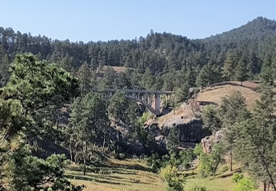
Beaver Creek Bridge carrying Route 87 established our course to Mount Rushmore. Though not a grey line, it wasn’t the route I previously planned to take. That and the other roads we took to reach our destination of Mount Rushmore provided ample entertainment. In addition to many curves and hills on narrow roads (competing for space with RV’s), we enjoyed a brief delay for a bison jam.
We also managed to pass through three tunnels (one with a view of Mount Rushmore) and a vista of Mount Rushmore from across the valley before reaching the parking lot. We learned our $10 parking fee is good for a year (we are unlikely to use it, but the receipt may be available for those interested).
After briefly visiting the monument, we popped into the Visitor Center to stamp our NPS Passport book. We closed out the night eating dinner and doing laundry. The hotel front desk manager was great at describing things in the area. We told him of our plans to visit Badlands National Park the next day and he suggested some things to consider. The conversation reminded me that this type of travel doesn’t always provide much in depth experience in a location.
September 7, 2025 – Rapid City, South Dakota
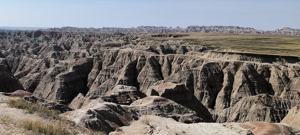
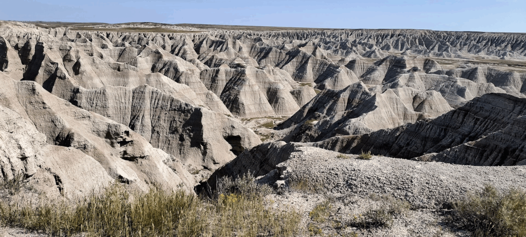
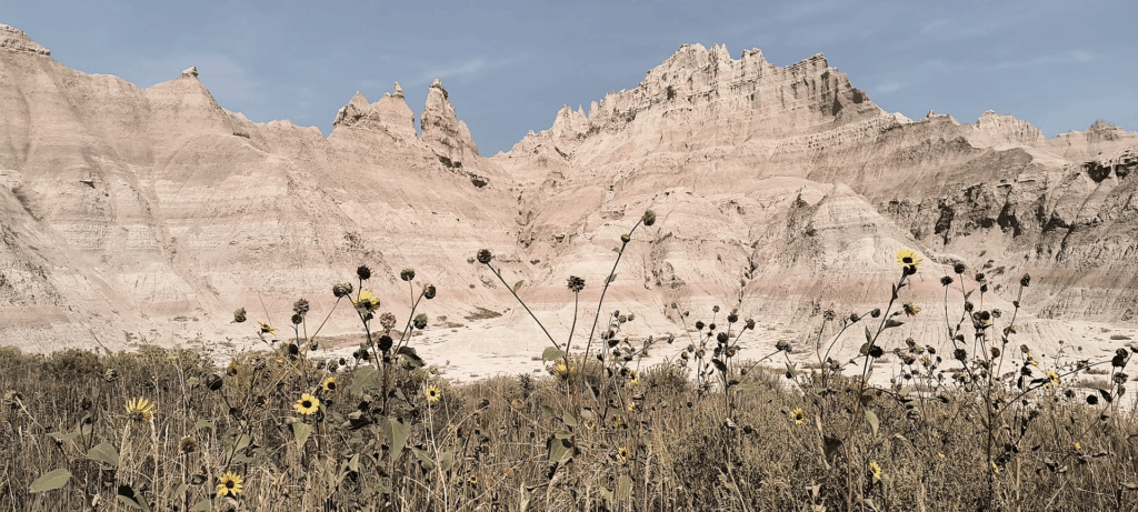
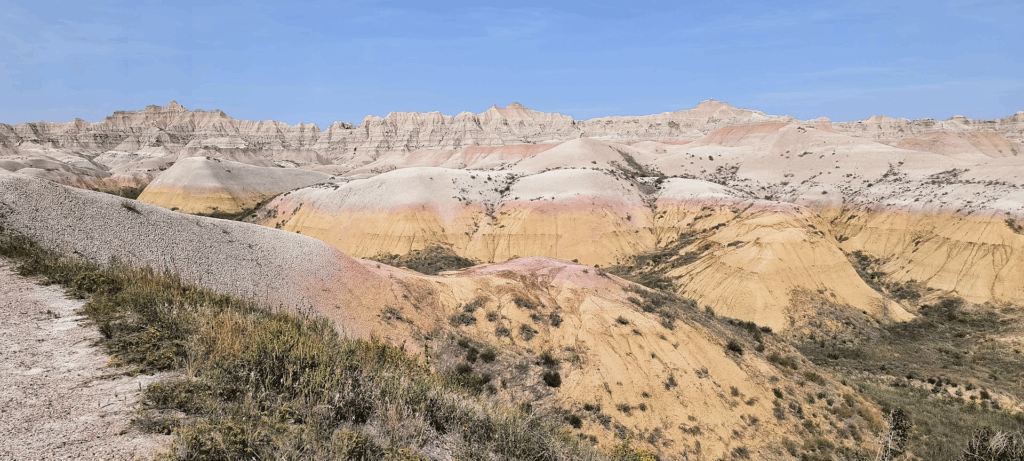
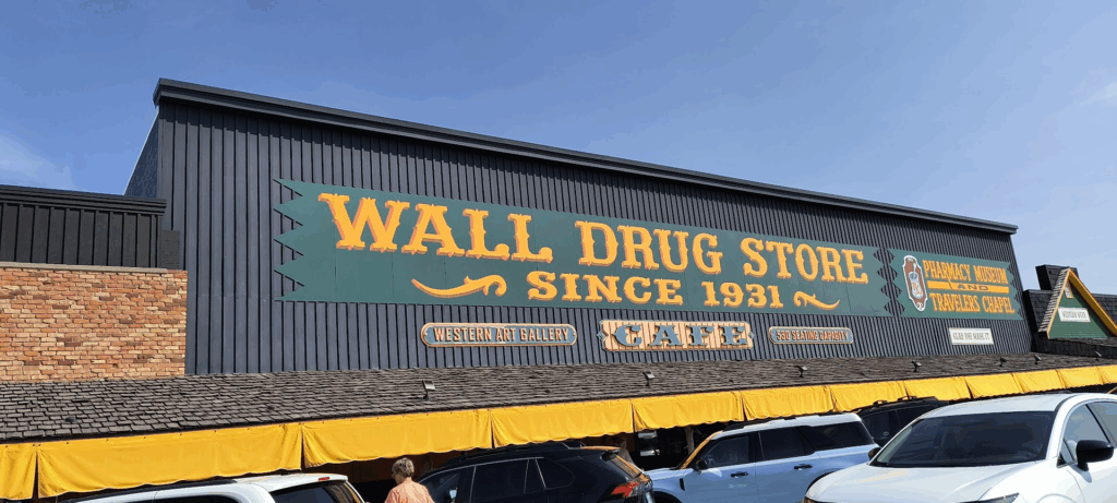
Today started out a bit more leisurely allowing for a midmorning arrival at Badlands National Park. Though featuring compelling scenery, we saw little wildlife. This was despite numerous signs warning visitors of the park’s inhabitants (rattlesnakes, bison, bighorn sheep, etc.). In the end we spotted one lone bison from a great distance. There were many Prairie dogs to be seen, but they didn’t warrant signage. One thing we saw a lot of were signs for Wall Drug Store. Their frequency and variety reminded me of South of the Border signs. Wall Drug Store consumes an entire block of Wall South Dakota. I only partially succumbed to the lure of retail therapy procuring a shake from the store’s malt shop (ironically in the cafe capable of seating 530 patrons).
Today’s journey was different in that we got (back) to the hotel before 5:00 PM (and we stayed in the same property two nights in a row). Needing to go an hour to the east to reach the Ben Reifel Visitor Center in Badlands National Park made that possible. I greatly appreciated only consuming five gallons of gasoline today (our least amount per day for this trip).
Badlands National Park is the second National Park in a row for us which acknowledged contributions of local indigenous tribes. Ben Reifel of the Sioux Tribe was also named Lone Feather serving five terms in the US House of Representatives.
We arrived at the park around 10:00 AM. While not sunrise, the lighting was good enough to enjoy a later start this morning. The Deer Trail (our second vista today) was so crowded I wondered about shoulder season in one of the country’s least visited states. Then I remembered today was Sunday. A staff member at the Visitor Center said the day of the week is a driver for park attendance.
Though today only had one primary objective, we had time for dozens of pictures taken at nearly every vista or overlook along the Badlands Loop Road. That volume introduces the problem of selecting pictures for the album and calendar. Even so, I anticipate many hours winnowing down hundreds of pictures to several dozen.
Badlands scenery is visually striking. I can only imagine the apprehension settlers felt looking up at the Wall they needed to summit from the plains below. Despite frequent signs warning about wildlife (rattlesnakes, bison, bighorn sheep, etc. ), we only saw one bison (from a great distance). No doubt had we chosen (and had time to) invest a few more hours into the park’s more distant locations we would have seen more four legged wildlife. A picture I was not able to obtain was of South Dakota’s fields of sunflowers – the state is noted for them.
We next ventured to Wall South Dakota to visit Wall Drug Store. For some travelers, that destination is a bucket list activity. Wall Drug heavily promoted itself with extensive highway signage (ala South of the Border) highway signage. Had our route not gone through Wall South Dakota today, I likely wouldn’t have made the effort. I was content sipping a shake on a bench outside.
We opted to eat out tonight at the Rapid City Olive Garden to use a gift card Cathy received. While not a James Beard destination, it met our needs. Even with the neverending salad, we only needed the first serving. Our leisurely dinner provided the opportunity to speak with our server who I asked about Rapid City. She (Alysa?) said she had only been in Rapid City for two weeks as she just started nursing school intending to land in ER duties. During the meal we revisited her plans. I always appreciate the opportunity to interact with hospitality staff. Their labor makes our travels possible (and much more enjoyable).
Early night to get ready for a 660 mile drive tomorrow.
September 8, 2025 – Rapid City, South Dakota
Bear Lodge, known by some as Devils Tower, has been on my bucket list since watching Close Encounters of the Third Kind (at a theater in the 70’s). Though we saw no extraterrestrial aliens, the weather cooperated for the images in this post.
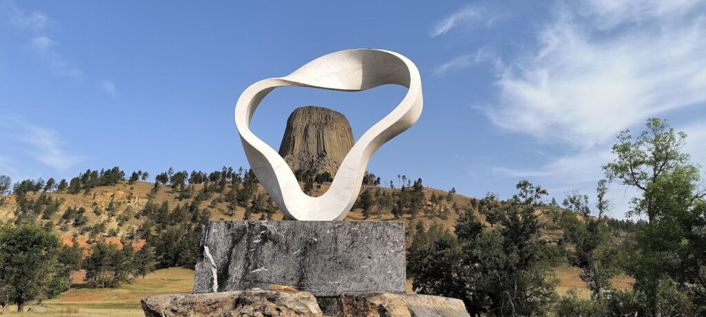
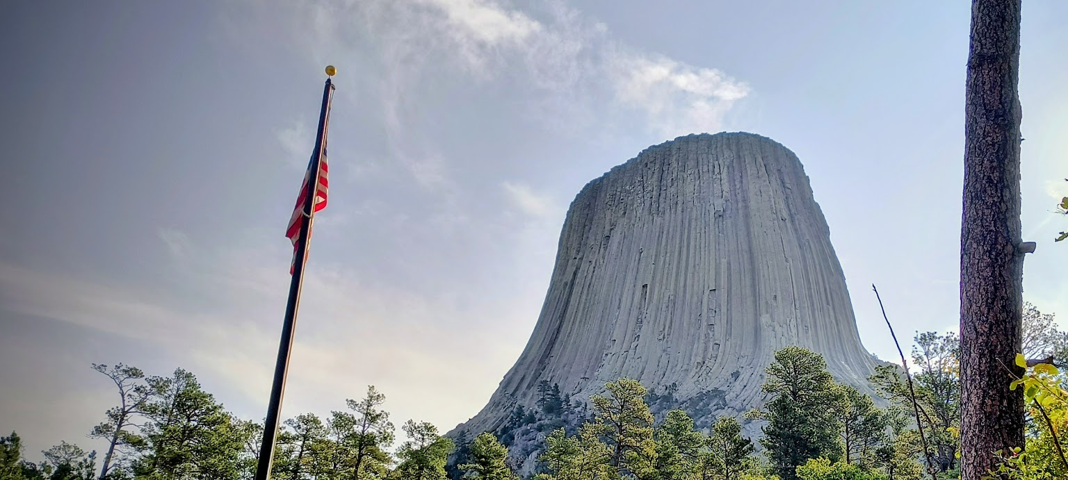
We woke before sunrise to start the lengthy drive to Helena Montana via Devils Tower. This morning returned us to Belle Forche (previously mentioned as the Center of the United States). It was conveniently on the way from Rapid City South Dakota to Devils Tower (which is called Bear Lodge by over 20 native tribes as a sacred site). The image below is of the Sacred Circle of Smoke donated by Japanese sculptor Junkyu Muto. His sculptures have been installed at the Vatican, the Mahabodhi Temple in Budha Gaya India and many other locales.
Our lengthy drive to Helena Montana limited our time at Bear Lodge to just over an hour (it takes a while to drive 660 miles – even when the speed limit is 85 MPH). The numerous pronghorn antelope made driving occasionally nerve wracking. Despite minimal road construction we didn’t arrive until close to 7:00 PM. Our nephew Jason and his family kindly delayed their dinner for our (late) arrival. It was great catching up with them. They were astounded we came by because “we were in the neighborhood”.
Tonight’s late arrival to the hotel introduced an unexpected problem. The hotel was sold through, but our room was available. Parking spaces in the comically small parking lot were not. We spoke to the front desk clerk who suggested parking in an adjacent business’ lot. That recommendation set off alarms about towing in my head. We ended up parking in front of the hotel’s garage door (which we were promised would not be a problem).
September 9, 2025 – Helena Montana
We scored a bonus state today. I didn’t remember you pass through a bit of Idaho on the way from Helena Montana to Park City Utah.
Thanks to my nephew Jason for recommending an alternate route through Island Park and near the Red Rock Lakes National Wildlife Refuge. We obtained much better images than we would from I-15.

The Helena Hampton Inn breakfast spread was so underwhelming that we checked out and ventured to a local establishment. The Breakfast Club is an egg oriented fast food joint complete with a drive through window. Made to order breakfast burritos (of which they offer over a dozen varieties) coupled with numerous hot / cold caffeinated beverages does not always make fast food. Nevertheless, it was far better than what the hotel offered that morning.
Our nephew Jason recommended we take a different route to Park City. This route included (mostly empty) surface roads to Island Park where we enjoyed the scenery and non-interstate experience. Alas, we too quickly returned to the interstate (and subsequently “experienced” Salt Lake City traffic congestion).
Tonight’s lodging being a studio in a property lacking a restaurant meant eat-in dinner choices needed to be ready to eat or microwavable. Fortuitously, Smiths grocery offered plenty of selections. It was nice to enjoy dinner on the balcony in the evening. The after dinner walk was somewhat abbreviated by the 7,000 foot elevation (we are sea level residents of this globe).
September 10, 2025 – Park City Utah
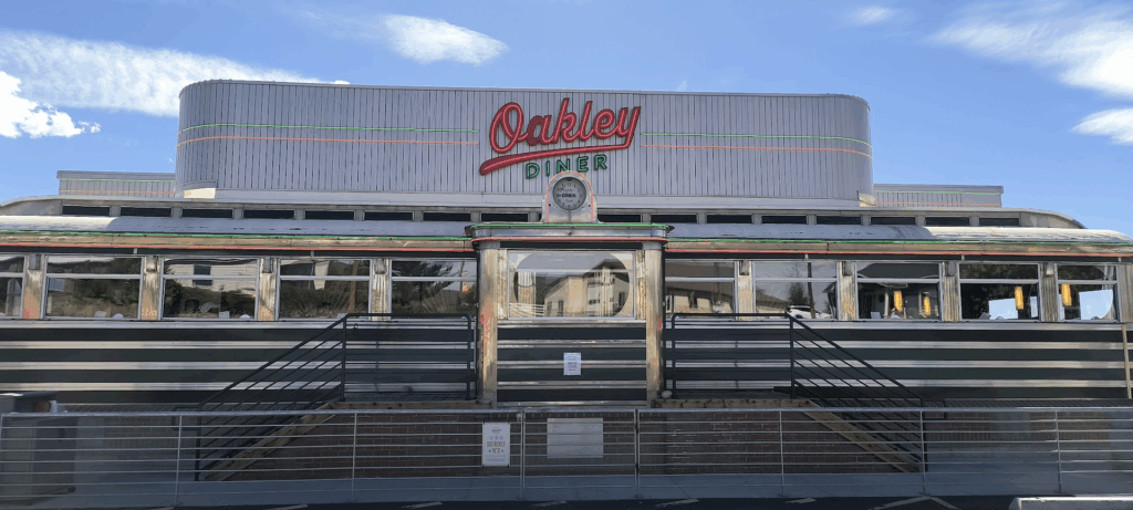
Today ended up being an eat out day. We went to the Oakley Diner for lunch. I enjoyed excellent fish tacos while Cathy devoured a Reuben.
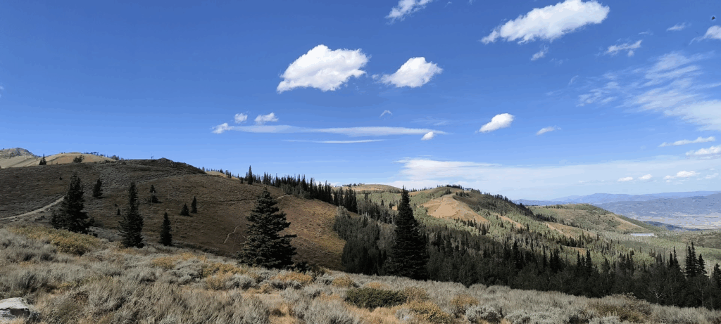
We then ventured to Guardsman Pass. A white knuckle journey up steep inclines and many tight curves on a very narrow road. We appreciated the view from the top (at 9,717 feet above sea level) before making our way back down to Park City.
Dinner was at the Boneyard with our nephew Zach and his wife Mackenzie. We always appreciate company, their dining recommendations and supporting local establishments.
It was nice not needing to pack up this morning and head down the road. That of course didn’t prevent us from rising early. One day we will sleep in at least until mid-morning.
We ventured east to Oakley Utah for lunch at the Oakley Diner. I found this gem courtesy of Atlas Obscura. The menu included classic diner offerings. I didn’t hesitate for the fish tacos nor did Cathy for the Reuben. I ordered a post-lunch chocolate shake for dessert.
Looking to fill time before dinner, we ventured to Guardsman Pass, at 9,717 feet above sea level. Getting up there involved continuous white knuckle driving up steep inclines and sharp turns. On the way up I accidently ended up on a 1 ½ lane steep residential street mostly blocked by a trailer. I know half the left side tires were hanging off the pavement (and am pretty sure the bushes on that side of the road prevented our tumbling down the mountainside).
The diving terror encore on the way down from Guardsman Pass was encountering an oversized tractor-trailor rig going uphill. I mostly went fully on the shoulder to pass the truck. Happily the driver stopped while we drove past. I have no idea if I broke mountain driving etiquette by not stopping for the truck to pass me. Thankfully we were on the mountain side of the road and not on the edge.
Tonight’s dinner took place at the Boneyard Saloon with our nephew Zach and his wife MacKensie on the roof patio. Mother Nature’s evening showers forced us inside. The atmosphere and food was good. My only complaint was not being carded despite prominent signage at the entrance stating everyone would be carded. When I asked about the discrepancy, they said “We were fine”. I’m not ready for AARP.
September 11, 2025 – Park City Utah
From Instagram post:
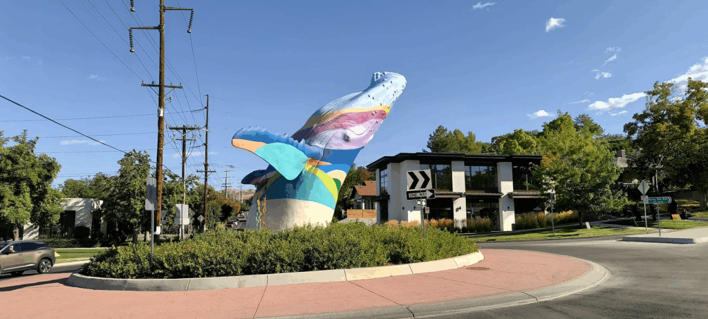
We discovered Salt Lake City boasts a prominent cetacean. Out of the Blue was installed in 2022. Ever since, local skiers considered it a deity as snowfalls have been considerably above average. We walked through the adjacent neighborhood observing numerous diverse eating and shopping establishments.
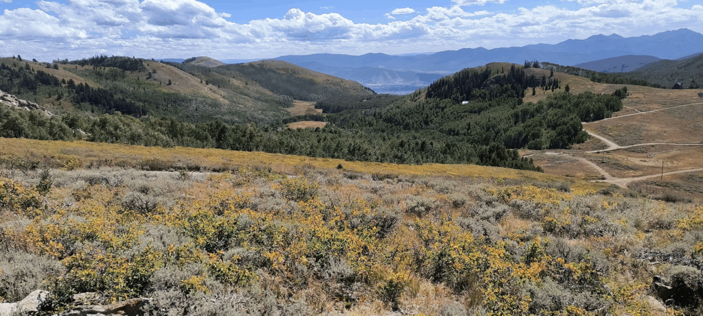
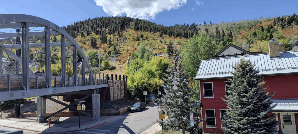
We returned to the main (e.g. tourist intensive) section of Park City. Our destination was the Bridge restaurant where we ate lunch on the patio. As you can see in the image, some of the trees are beginning to turn.
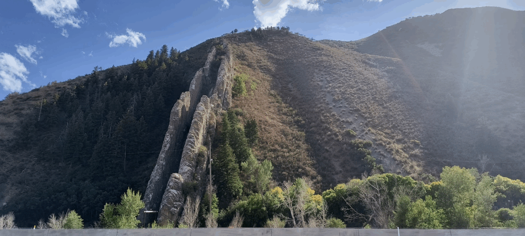
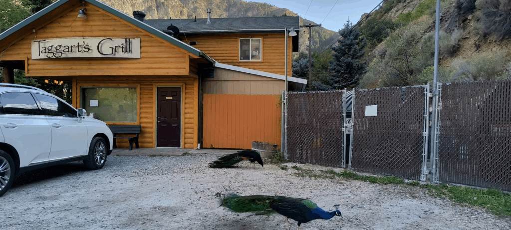
I arranged to have dinner at Taggart’s with a former coworker. On the way, we stopped by the Devils Slide (a huge limestone slide – conveniently at a highway viewpoint).
The peacocks were an unexpected perk at Taggart’s.
Like some days in this trip, planned things didn’t happen and unplanned destinations were added. Of the four destinations today, only one was in our original trip plan. One came from our nephew at dinner the night before. Another via a text this morning from Cathy’s brother and the last as a result of my researching this morning for an interesting place on the way to dinner.
We enjoyed our second consecutive morning in the same property without needing to pack up and check out. About the only morning downside was a breakfast of cold cereal and coffee I made. The alternative is to dine out which would have easily exceeded $40 for us both. My congenital frugal nature made it easy to eat in the room this morning.
Our nephew Zach strongly recommended we visit Salt Lake City’s 9th & 9th neighborhood to observe the Out of the Blue sculpture of a life size blue whale emerging from a traffic circle. After the obligatory picture taking (below), we walked a few blocks down this quirky neighborhood street. The variety of diverse establishments was pleasantly out of sync with my expectation of a very culturally conservative city (in an even more conservative state). I found the variety of restaurants and stores reminiscent of Richmond’s Carytown neighborhood.
The grid system for roads in Salt Lake City certainly establishes order. At the same time it struck me as unoriginal. In fact Google Maps couldn’t reconcile our tuning left off 1300 East to 1300 South and didn’t display the road name simply instructing us to take the next left.
At my brother in law’s recommendation, we had lunch at the Bridge Cafe in Park City. The people density of this tourist mecca is unsettling. We could only handle walking a few blocks on Main Street before adjourning to the Bridge Cafe’s patio for lunch. I mistakenly didn’t wear a long sleeve shirt which made the breezes uncomfortably cool. Even so, I enjoyed eating outside away from foot traffic.
Later that day sitting on the balcony of the resort I heard the wind rustling the Aspen leaves in the courtyard below. The Aspen trees were just a few weeks or so away from reaching peak color.
On the way to dinner with a former co-worker, we pulled off the I-84 viewpoint to observe the Devils Slide. (a find from my research). While visually interesting, standing right next to an 80 MPH highway with virtually no separation from the traffic meant I likely wouldn’t have driven to it were it not on the way to Taggart’s Grill just a couple of miles west at an oddly placed location. There was nothing other than a river launch site and a surprisingly large parking lot for the restaurant. The peacocks strolling around the crew shooting a video for a TLC production added to my curiosity. I need to find that show once it airs.
September 12, 2025 – Park City Utah
Today we drove from Park City to Moab. On the way we stopped for lunch (in the car) at Helper Utah. The filling station was right across the street from where we stopped.
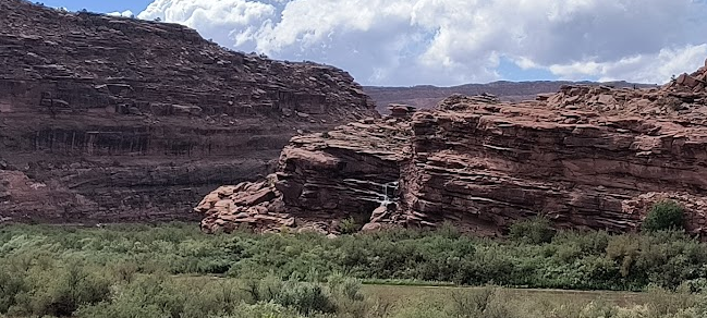
We then drove through a section of Utah that had he seen it, I am confident it would have inspired Tolkien for Mordor. Curiously, just a few miles down the road, grasslands reappeared. Just before we reached Moab, an epic storm unloaded on us. Both our phones were sending flash flood alerts. If you look closely, you can see a small waterfall from the runoff (one of hundreds we saw today).

Today we traveled from Park City to Moab Utah. Just like we appreciated three nights in one location, Moab provides us a full week of lodging (of course each day there includes multiple hours of driving).
The drive to Moab went via Provo where we stopped at St. Mary’s Episcopal Church to view their notable stained glass. Alas, we arrived before the sanctuary opened that day. A planned lunch stop in Helper Utah took us down Route 89 through valleys and over mountains where we saw leaves beginning to turn. Highway warning signs of cattle open range got our attention. Major downpours in Moab triggered flash floods. The storms didn’t force route diversions, but created hundreds of muddy waterfalls off the cliffs above Moab.
Our getting into our room nearly three hours early allowed us to reconnoiter the room confirming it included a full kitchen. That finding enabled grocery shopping for multiple dinners in the room. We bought pasta, sauce and meatballs for spaghetti to accompany salad, bread and wine (not bad for a “roughing it” excursion).
September 13, 2025 – Moab Utah
For those who have not been to Arches National Park, I strongly recommend adding it to your bucket list. Our lodging is just five minutes from the park entrance providing us the ability for repeat visits (after we see the other “local” National Parks in the area). The only downside to a repeat Arches visit is the need to arrive before 7:00 A.M. as no morning timed admission tickets remain available this week. As we both are early risers, that shouldn’t be too difficult.
Another challenge was curating several dozen images into the handful selected for this post. Fear not, I am compiling a Google Photo album (which will also include selected SLR images) so you can enjoy the complete set.
Climbing out of a murphy bed in the dark takes some dexterity. While an excellent use of space, the bed’s mattress was only somewhat better than a sleep sofa. In just the few hours of daylight we were in Moab, it was hard to miss differences from Park City. While both cities attract somewhat overlapping demographics, it seemed to me the Moab crowd was not too much into high fashion.
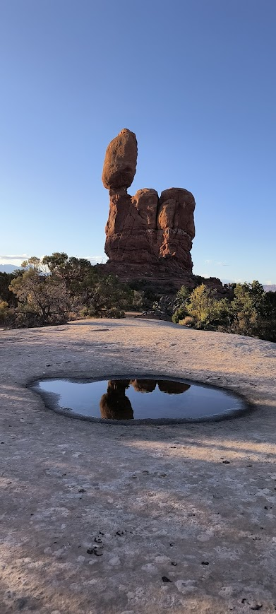
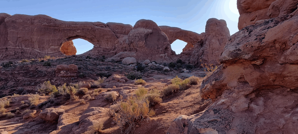
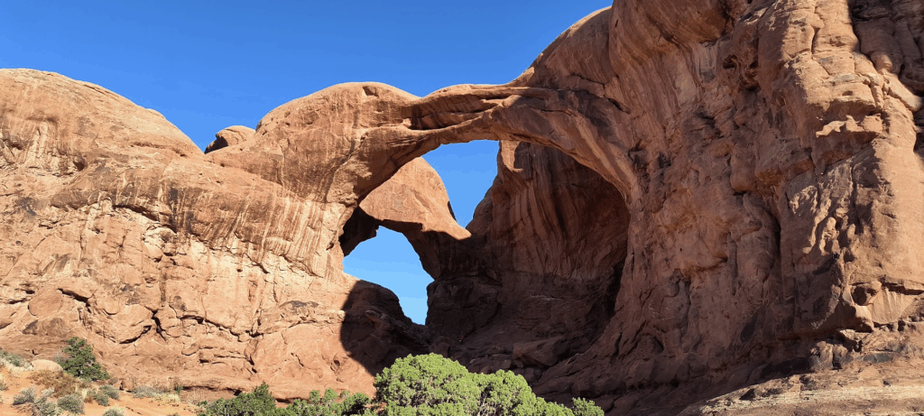
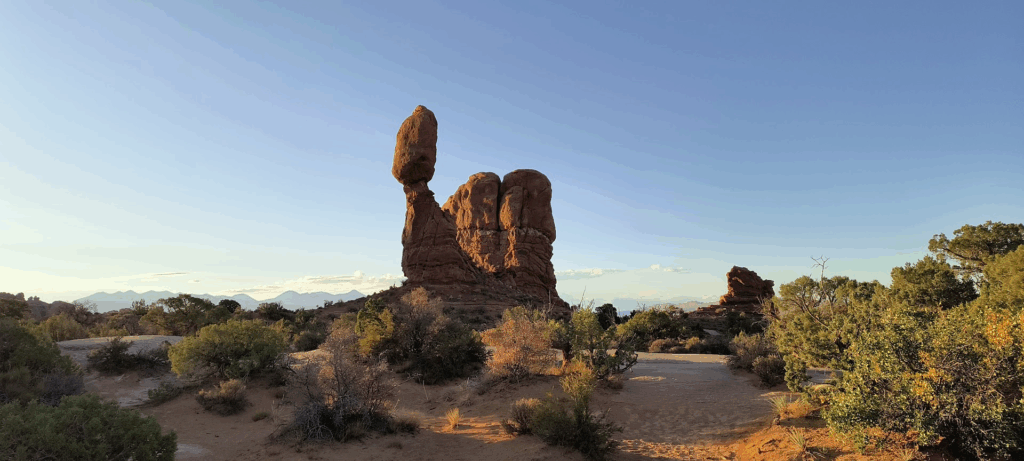
Arches, arches and more arches. Apparently Arches National Park contains over 3,000 arches. What an inventory. Perhaps the most unexpected arch was Sand Dune Arch. It reminded me of Petra containing more sand than other parts of the park we visited (despite the park being in a desert).
We bumped into a couple from Scotland at one vista. Their itinerary, though longer in miles (because of flying), included fewer National Parks than our trip. Interestingly some of their destinations included places we planned to visit and others such as Antelope Canyon we visited years ago. Their descriptions of how Delta Airlines employees treated them made me embarrassed to be an American and I said that. They said they weren’t too stressed about the experience.
We contemplated the three mile out and back hike to Delicate Arch, but decided to save that adventure for another day taking advantage of the park’s proximity to our lodging. The out and back design of Arches National Park scenic road provided the opportunity to skip views and arches if the parking lot was too crowded. We ended up visiting every intended destination until storm clouds prompted our exit from the park.
On a whim we decided to try the Moab Brewery which Cathy’s brother recommended we visit. It was rather strange reviewing an extensive list of beers that all with no more than 5% alcohol (due to Utah alcohol regulations). Our arrival timing was good as the previously mentioned storm hit Moab just as we ordered our meal. I estimated at least an inch of rain fell in less than an hour.
September 14, 2025 – Moab Utah
From Instagram post:
The first image is from our balcony looking towards the Colorado River in Moab. I didn’t see the fog yesterday because it was dark when we left.
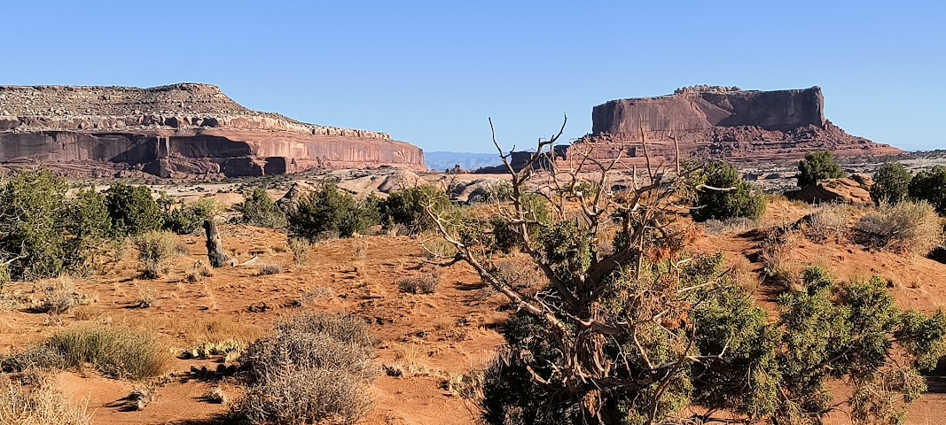
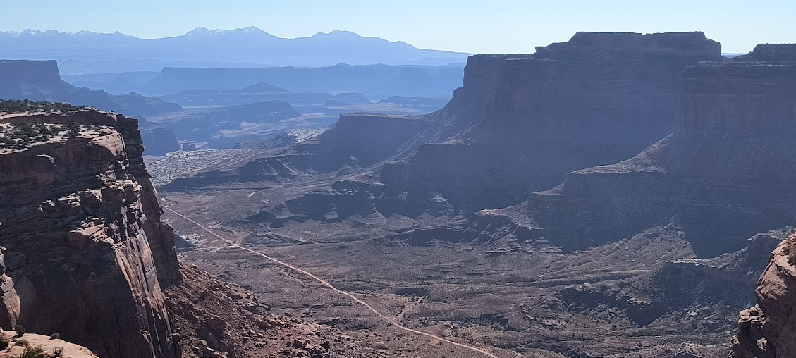
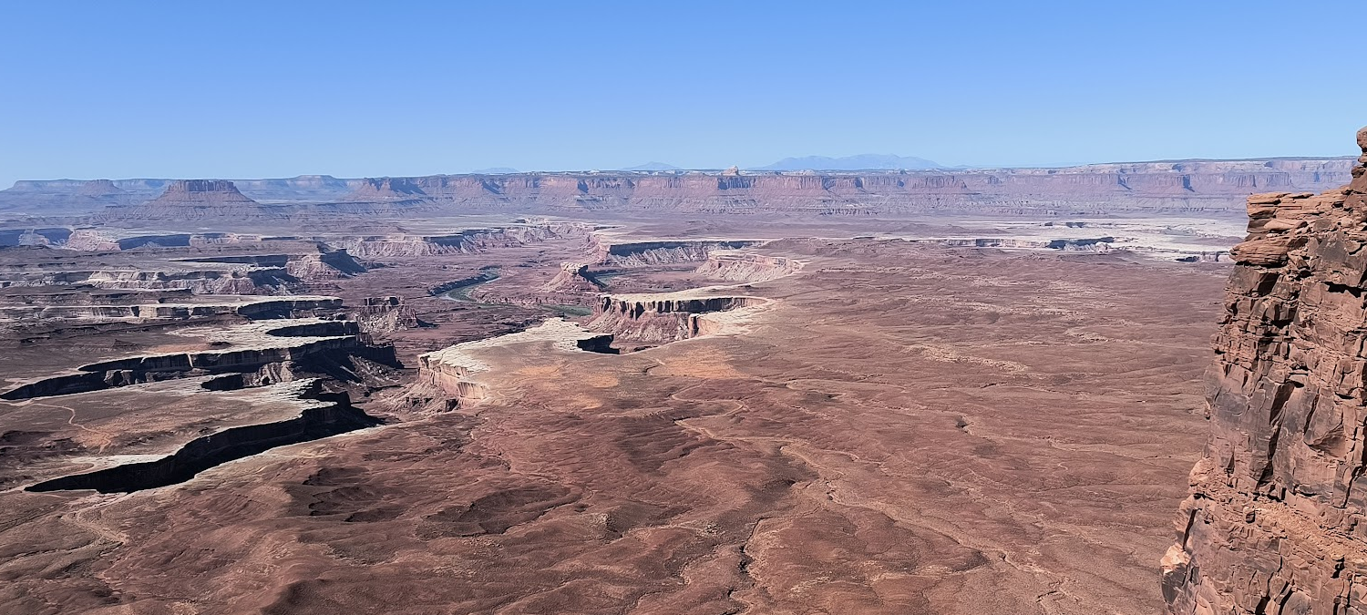
The second image is classic Utah outdoors. Nearly all the 30+ miles from Moab to before we reached the Island in the Sky visitor center of Canyonlands would have been worthy of National Park status east of the Mississippi. This is but one of dozens of similar views we passed.
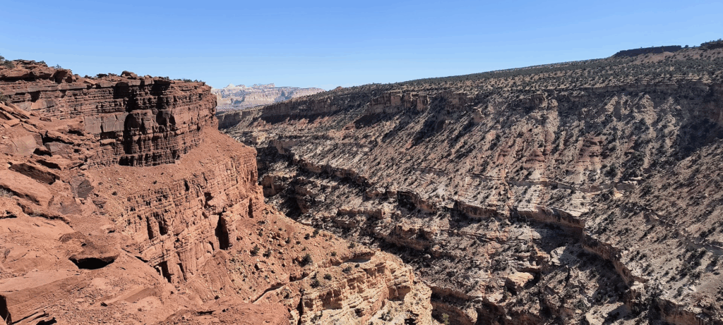
Canyonlands contains four districts of which we only visited Island in the Sky (primarily due to not driving an off road vehicle and time). The name is apt given the middle images. Basically we drove on a peninsula separating the Colorado and Green rivers. We were over 1,000 feet above both rivers on the “island”).
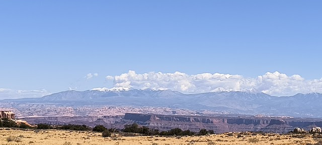
The last shot is of snow on the La Sal mountains in eastern Utah. I didn’t expect to see snow this early in the (winter) season.


We lucked out with yet another outstanding clear morning. Though not as close to Moab as Arches, Canyonlands National Park was just over half an hour away. I was struck by how scenic the drive was outside the national park. That seems to be a theme in Utah. I was relieved that despite National Park App warnings, long lines at the entrance weren’t in place when we arrived. As a example of the remoteness of this part of Utah, the most visited center in Canyonlands NP relies on pit toilets. Though they lacked plumbing, all other supplies at the visitor center were readily available. I commented to the cashier about the pleasant weather. She said yesterday it sleeted and hailed with a tornado mixed in (talk about timing). Clearly Moab got the better end of the weather stick yesterday.
The lack of lines at the park entrance didn’t mean the park was empty. Most parking lots were full, forcing waits for a parking spot. The parking lot at Mesa Arch (one of my targets) was full each of the four times we went by. After not being able to enter the Mesa Arch parking lot, we diverted to Upheaval Dome. This geologic curiosity is an example of rocks pushed up into a circular structure called a dome, or an anticline. The reason for this variation is reported to be something called the Salt Dome Theory where salt from ancient seas flowed up through rock layers as a “salt bubble”. Another theory is an impact crater from a meteor strike about 60 million years ago. Our primary objective was a place to eat lunch (other than the car). We scored the last open parking space and last unoccupied picnic table. After lunch we went up to the trailhead to read up on Upheaval Dome. Had we mobile network coverage, I would have done that at the picnic table (and perhaps not done the walk). We noticed the first viewpoint (image below) was .3 miles away (up hill). I decided to walk up to the view (below) concluding the hike felt far longer than .3 miles. Between the elevation gain and a 6,000’ starting point no doubt meant the reduced oxygen levels had a lot to do with that feeling.
Our plans today included a visit to Dead Horse State Park which is also known for its views. Being on the opposite side of the Colorado River from Canyonlands should make for interesting sunset photographs. Knowing we planned to visit Goblin Valley State Park the next day, I asked the attendant if Utah State Parks offered deals like in Virginia where your admission in one park is good for another park within 24 hours (something I used in Virginia last year). Alas, the attendant said admission at Dead Horse State Park was only good for that park. I decided the $20 fee for a planned hour in the park wasn’t the best use of our funds. Dinner was in our room (courtesy of the full kitchen and our grocery shopping). Knowing we had a long day in the car the next day, I was fine ending our travels a bit earlier.
September 15, 2025 – Moab Utah
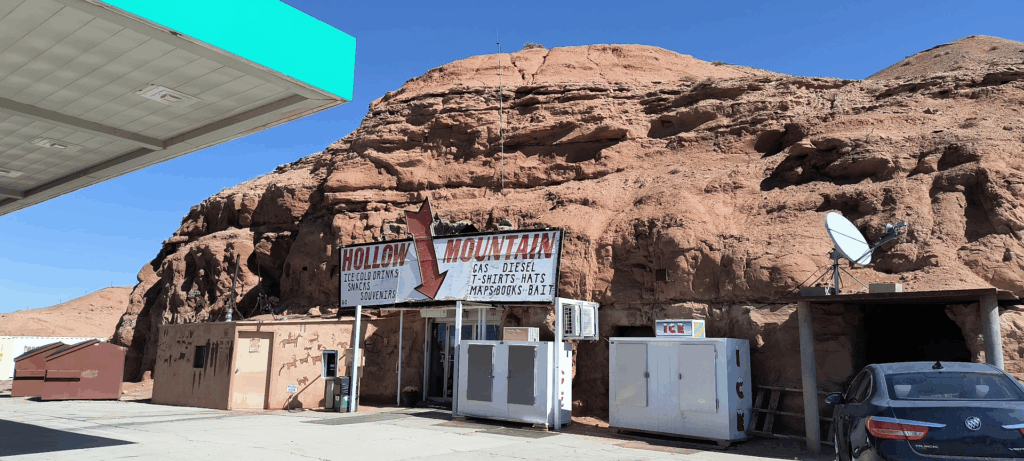
Goblins, Hollow Mountain and a reef!!!
Today we traveled from Moab to Capital Reef National Park.
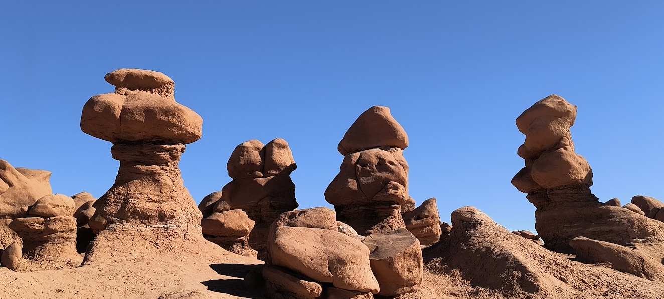
On the way we stopped at Goblin Valley State Park. Those who remember the movie Galaxy Quest may recall this location. Though we didn’t see Gorignak, evidence of his minions were scattered throughout the valley.
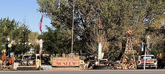
We escaped Goblin Valley briefly ending up in Hanksville Utah where we discovered a hollow mountain. Down the road and across from the post office we considered but passed on visiting some americana in the form of the Monster Mountain Kingdom.
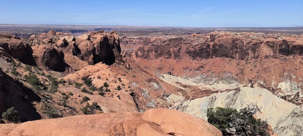
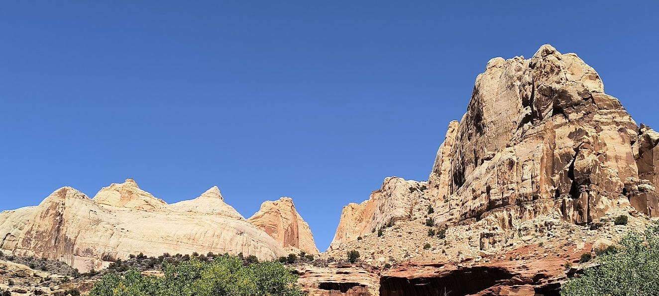
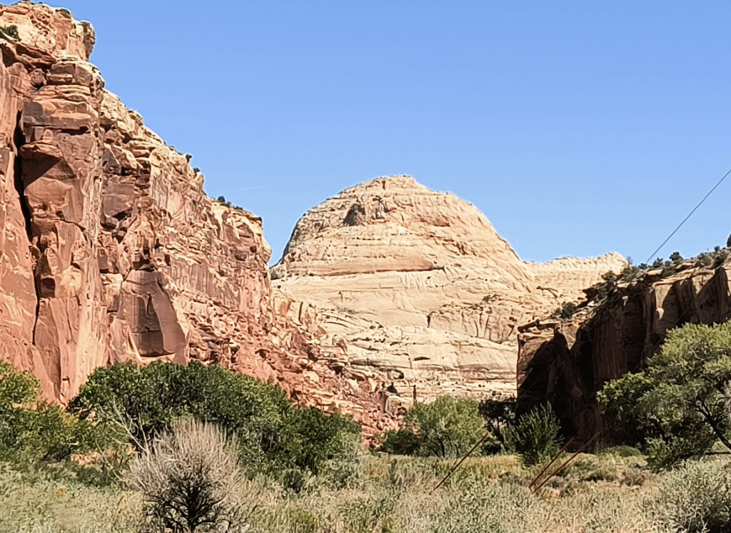
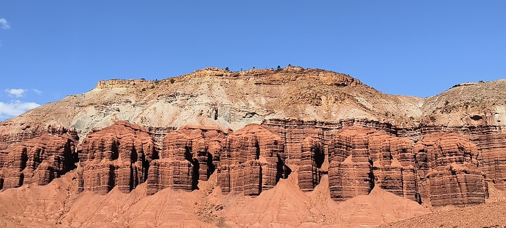
All these diversions prepared us for Capital Reef National Park. For those unfamiliar with the name, one feature reminded some of the Capitol dome. The reef comes in from the Waterpocket Fold creating a 100 mile barrier like a barrier reef in the ocean. Capital Reef was as visually appealing as the other parks we’ve visited.
Today we crammed in multiple trip destinations and positioned ourselves for visiting Bryce Canyon National Park (which will make four National Parks in four days). Because Bryce Canyon National Park is a four hour (one way) drive from Moab, we found a Hampton Inn in Richland Utah (a mere two hours to Bryce – alas there was no closer Hilton property to Bryce). Nevertheless, tomorrow will require a few hours less in the car. It was kind of weird leaving most of our stuff in Moab just packing what we needed for two days on the road. What was truly weird (and somewhat disconcerting) was passing a sign on I-70 stating “No Services next 100 miles”). I noticed a similar sign leaving Hanksville Utah on the road going south for 140 miles without services.
In addition to five top tier National Parks, Utah claims several compelling state parks. Knowing Goblin Valley State Park was literally on the way to Capital Reef National Park, it was a no brainer to stop by for a short visit. Those who watched Galaxy Quest may recall an extended scene on Epsilon Gorniar II where Jason Nesmith was nearly crushed by a Gorignak. Had we had more time, I definitely would have enjoyed walking through more of the park. As it stands, you can enjoy some of our pictures of what was at one time called Mushroom Valley.
We got to the Capital Reef National Park Visitor Center before noon. It was unexpected not needing to pass through a park admission gate. The routing of SR 24 right through the park (and past many of its most significant features) made it hard to justify charging admission. Despite being a non-weekend day in the shoulder season, the crowds at Hickman Bridge (another photography target of mine) prevented me from hiking to see this feature. You have to make do with another photographer’s image of Hickman Bridge. That and hot temperatures late in the day and needing to drive 90 miles to Richfield Utah meant we were only in the park for about three hours. The Richland Hampton was perfectly satisfactory (gotta love using points). We went to the Black Bear Diner for dinner, returning to our room too stuffed for dessert.
September 16, 2025 – Richland Utah
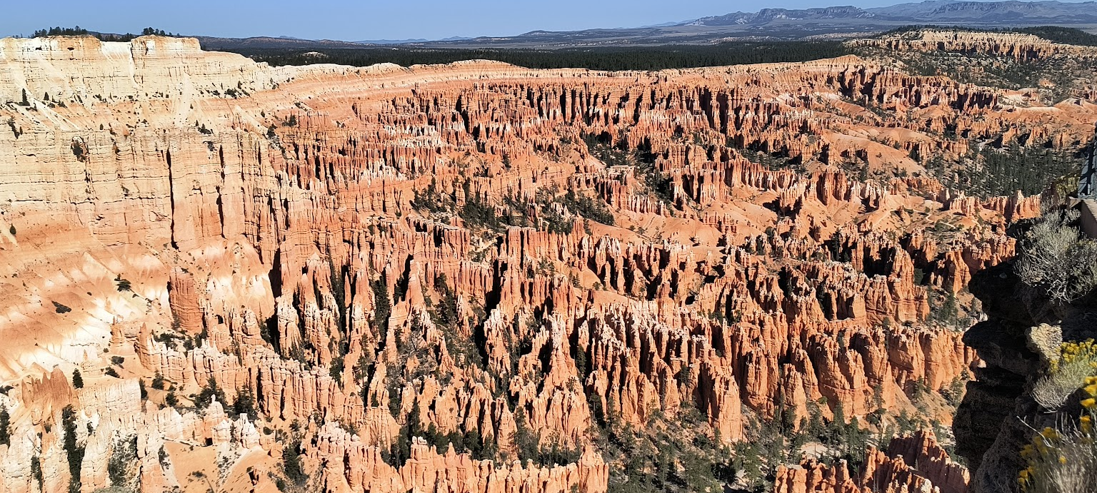
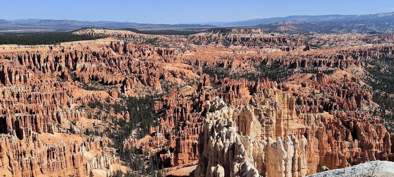
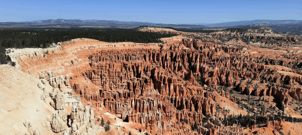
Hodoos as far as the eye can see
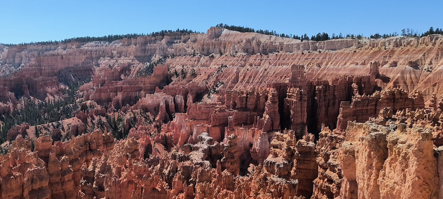
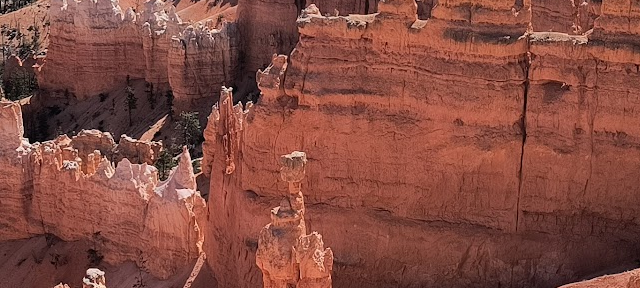
Unka-timpe-wa-wince-pock-ich, the Paiute phrase for “red rocks standing like men in a bowl-shaped recess” (known by many as Bryce Canyon National Park) contains in its amphitheater more Hodoos than any place on the earth. One notable Hodoo is named “Thor’s Hammer” (for obvious reasons). Otherwise what you see may appear as sand drip castles.
Similar to my Arches post, I had great difficulty curating the selection for today’s post. Between my phone and my SLR, over 100 pictures were taken at Unka-timpe-wa-wince-pock-ich.
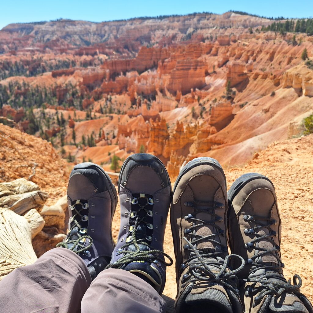
I am particularly happy that two experienced people (I won’t use the three letter word referring to our demographic) walked the Rim trail to obtain these images. Enjoy.
Writing some of today’s entry first thing this morning because Cathy took the first driving shift on the highway. The hotel location right next to the highway made for an easy start. Parking at Bryce Canyon National Park may be problematic necessitating the use of the park’s shuttle bus station outside the park. We enjoyed striking scenery on SR 89 from Interstate 70 along the Sevier River deep in canyon walls with a long risen sun high on the canyon rim. Once we passed Beaver Creek, the canyons ended and the landscape opened up to an agricultural setting. The stench from driving past the industrial hen houses reminded me that Utah doesn’t rely entirely on the hospitality sector. We passed yet another significantly depleted reservoir. Presumably they are replenished in the winter. We then drove through Circleville Utah (where Butch Cassidy was raised). Cows walking alongside the road reminded me this is open country range. After Circleville, the landscape along SR 89 returned to narrow canyons.
I really appreciated the multitude of serviceable rest areas out west. Unlike east of the Mississippi, these rest areas aren’t limited to interstate highways. That was a good thing since much of our driving in Idaho, Utah and Colorado wasn’t on interstates.
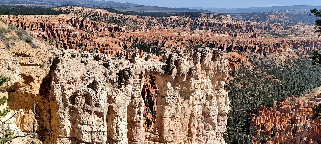
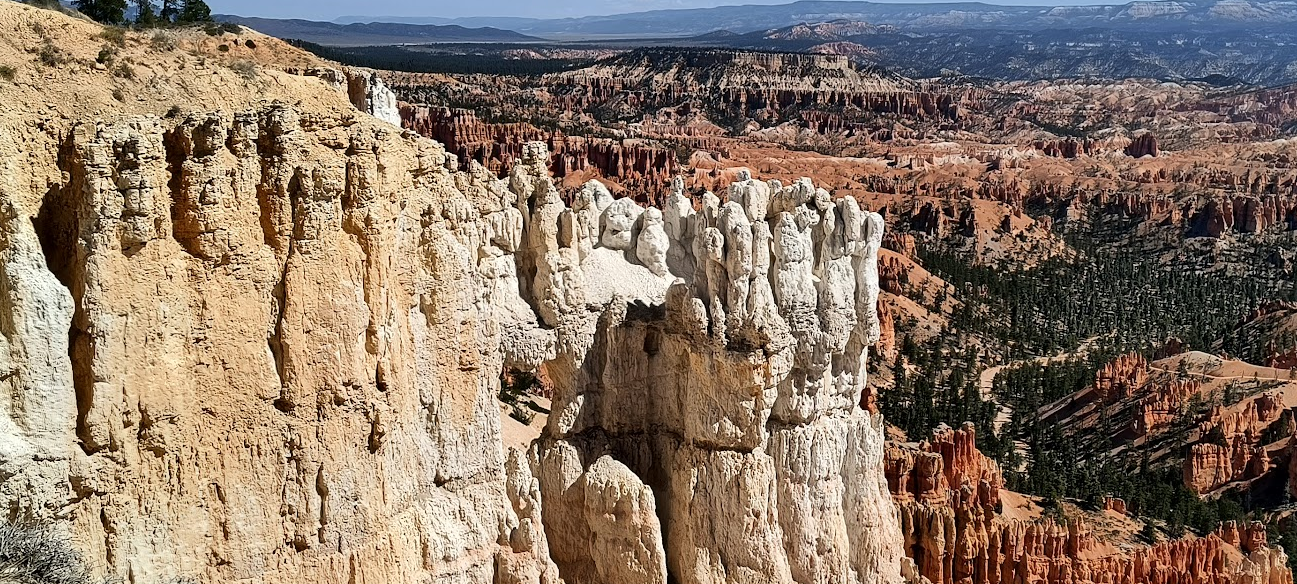
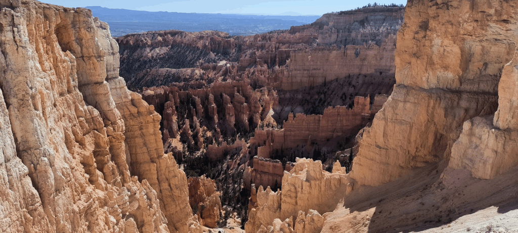
We opted for the shuttle buses offered by Bryce Canyon National Park. Similar to yesterday, nearly every viewpoint parking area was slammed. We took the shuttle to the end of the route at Bryce Point and walked nearly the entire Rim Trail back. Fortunately, our route included downhill segments. At various viewpoints we watched those hiking the adventure trails down in the canyon below us. The image below illustrates our (tired) state of mind when we reached the trail’s endpoint for the day.
While the translation of the Paiute phrase Unka-timpe-wa-wince-pock-ich, for “red rocks standing like men in a bowl-shaped recess” is great, I understand the basis for the westernized (e.g. American) name of Bryce Canyon. We must have taken over a hundred pictures of the many Hodoos in Bryce Amphitheater.
Exiting Bryce Canyon NP I thought about how well the shuttle bus system worked and wished something similar was viable for more National Parks. Bryce Canyon NP and Zion NP use shuttle buses, but those park’s configuration and popularity make that feasible. Arches out and back configuration could benefit from shuttle buses. I believe that the park’s timed admission rate could be expanded through the use of shuttle buses.
The ride back to Moab was over 4.5 hours of mostly new roads for us. We stopped at a very windy (and somewhat chilly) overlook that we passed on SR 72 to stretch our legs. The downhill stretch on I-70 east of Green River was quite intense. I appreciated pulling into our lodging in Moab to decompress over a glass of wine.
September 17, 2025 – Moab Utah
After four consecutive days of National Parks, we went to a swimming hole. We didn’t fully immerse ourselves, but needed to ford the creek four times ensuring our feet were wet. The Mill Creek Waterfall is but 4 miles from our lodging. One of the Google reviewers described it as a short hike from the trailhead. At over a mile, it was far more technical than we expected.
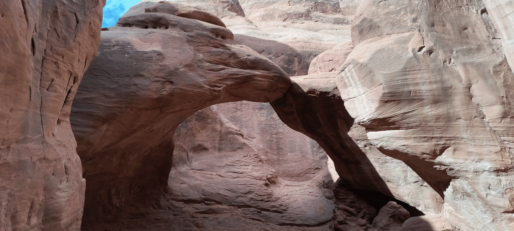
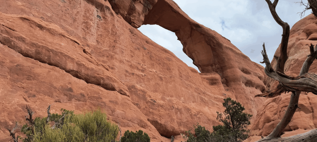
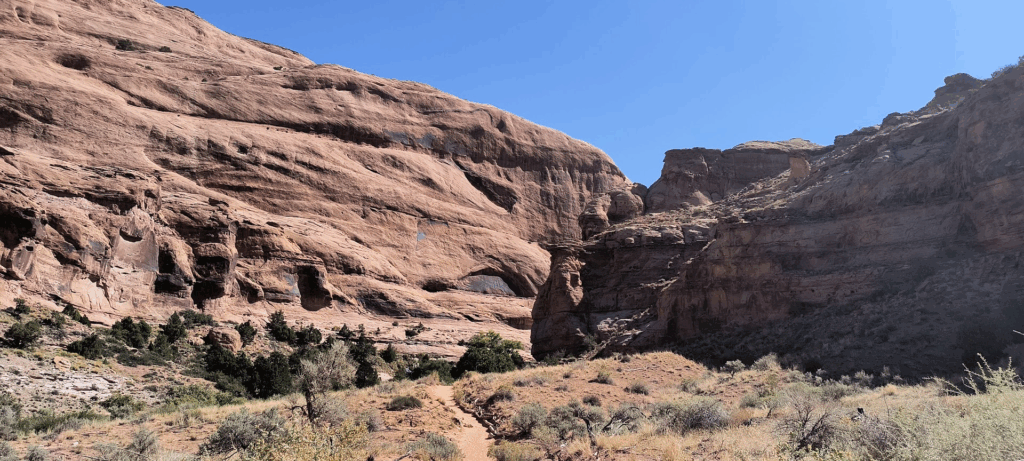
Being shut out two days in a row for arch hikes at Capital Reef and Bryce Canyon, I decided to walk up to Wilson Arch. That route was understandably technical (which didn’t make it any easier).
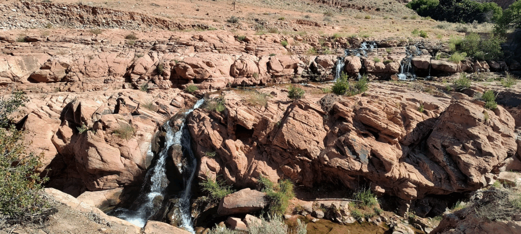
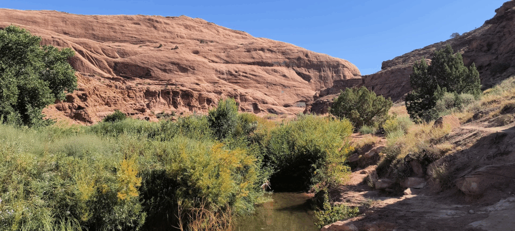
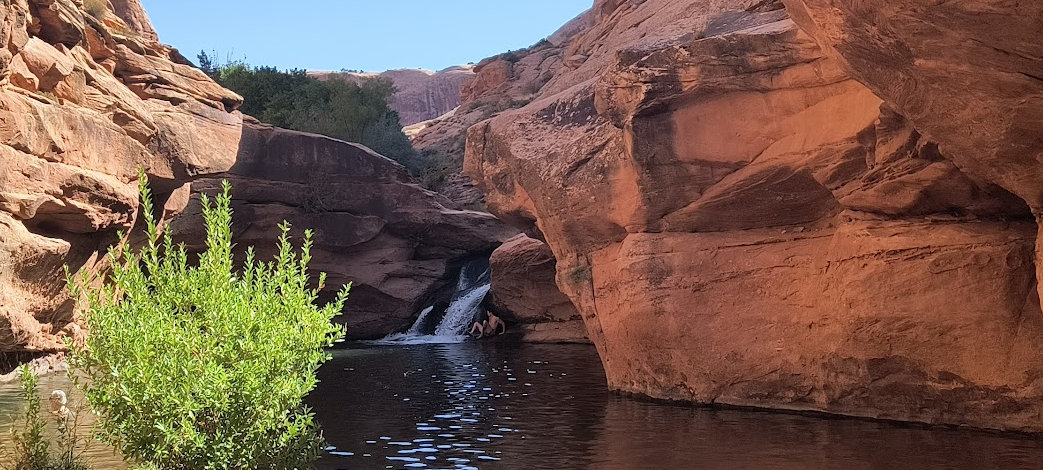

We’ve been so fortunate with the weather. Basically every morning has been clear (or at least no precipitation). Unlike the past four days, we will hang in (or near) Moab today. I planned for a walk up to the Mill Creek Waterfall this morning to beat the predicted upper 80’s afternoon temperature. We got to the trailhead around 10:30 (like I implied, we are taking an off day – at least for us). My research on the hike indicated it was a short hike. At just over a mile, fording the creek four times (ensuring our boots got wet) and traversing unexpectedly technical rock climbs, we encountered someone affiliated with the state park system from Moab Trail Ambassadors. She confirmed our distance to the falls and the need to ford the creek (two more times). The swimming hole and beach were rather compact. I’m certain it’s a full house there in the summer. Only limited parking at the trailhead would prevent total mayhem during peak season. On the walk back we passed a few older women (I have no idea how they got that far). They seemed to be doing OK. Ironically we next encountered a woman at the first hard section of the trail that was part of that group. She decided to rest there in the shade until the group returned. That seemed a wise choice.
My only other destination today was Wilson Arch. This arch was named after a Dry Valley pioneer named Joe Wilson. My research also indicated reaching it involved “easy” scramble up red dirt (which I question). Unlike the arches we’ve seen over the past four days, this was right next to a major road (for eastern Utah – SR 191) and just down the road from Moab. The climb up wasn’t on a marked trail. I mostly went where I saw the most footprints. Upon reaching the top, I took some obligatory photographs (above). The trek down was just as technical. Choosing a different route didn’t make it any easier.
We ended the day enjoying the resort’s hot tub. A fellow who joined us said he was from Zuni, Virginia. He was there with some of his family enjoying Utah’s natural resources. It was kind of neat connecting with someone from Virginia.
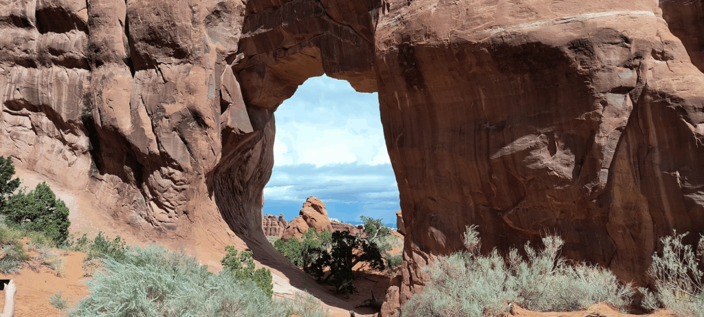
September 18, 2025 – Moab Utah
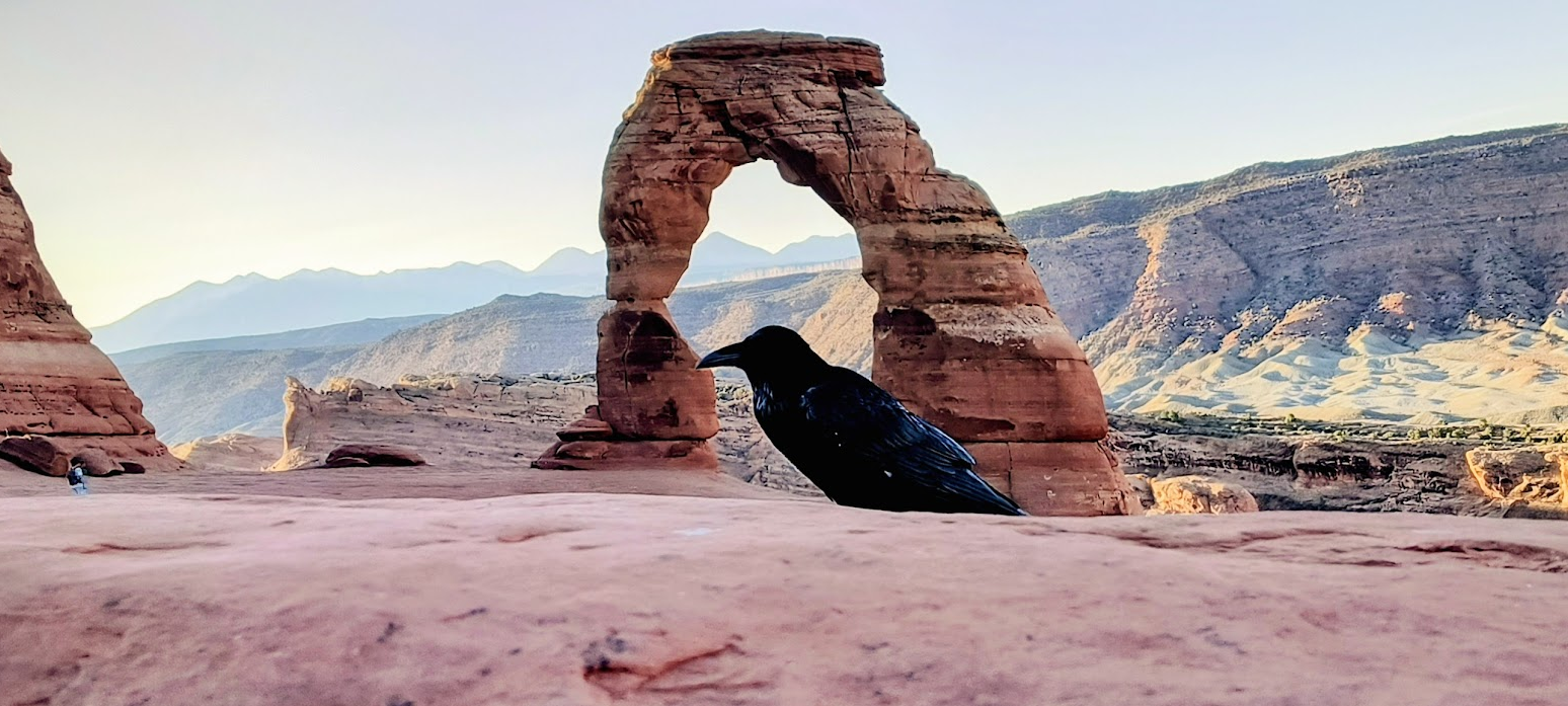
Thus quoth the raven
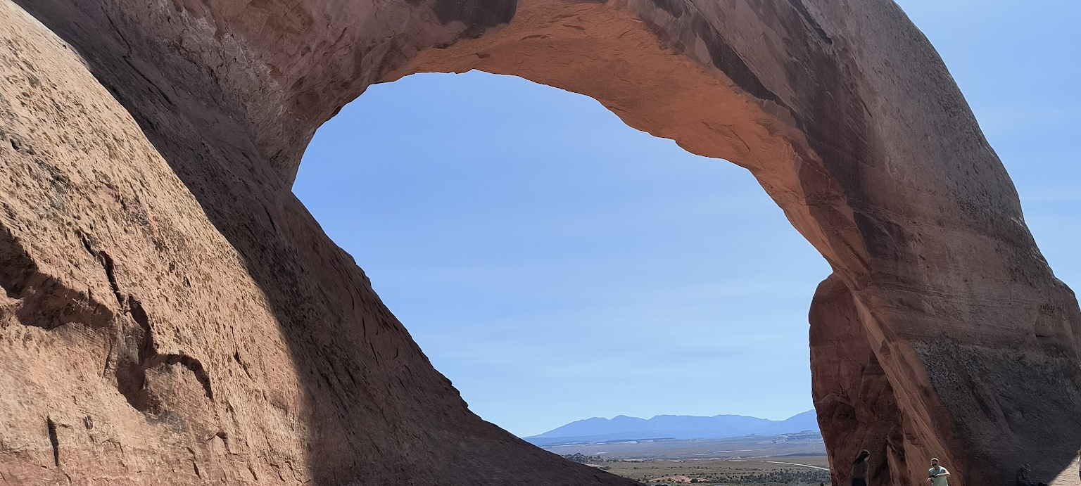
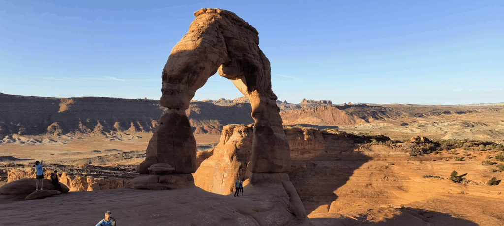
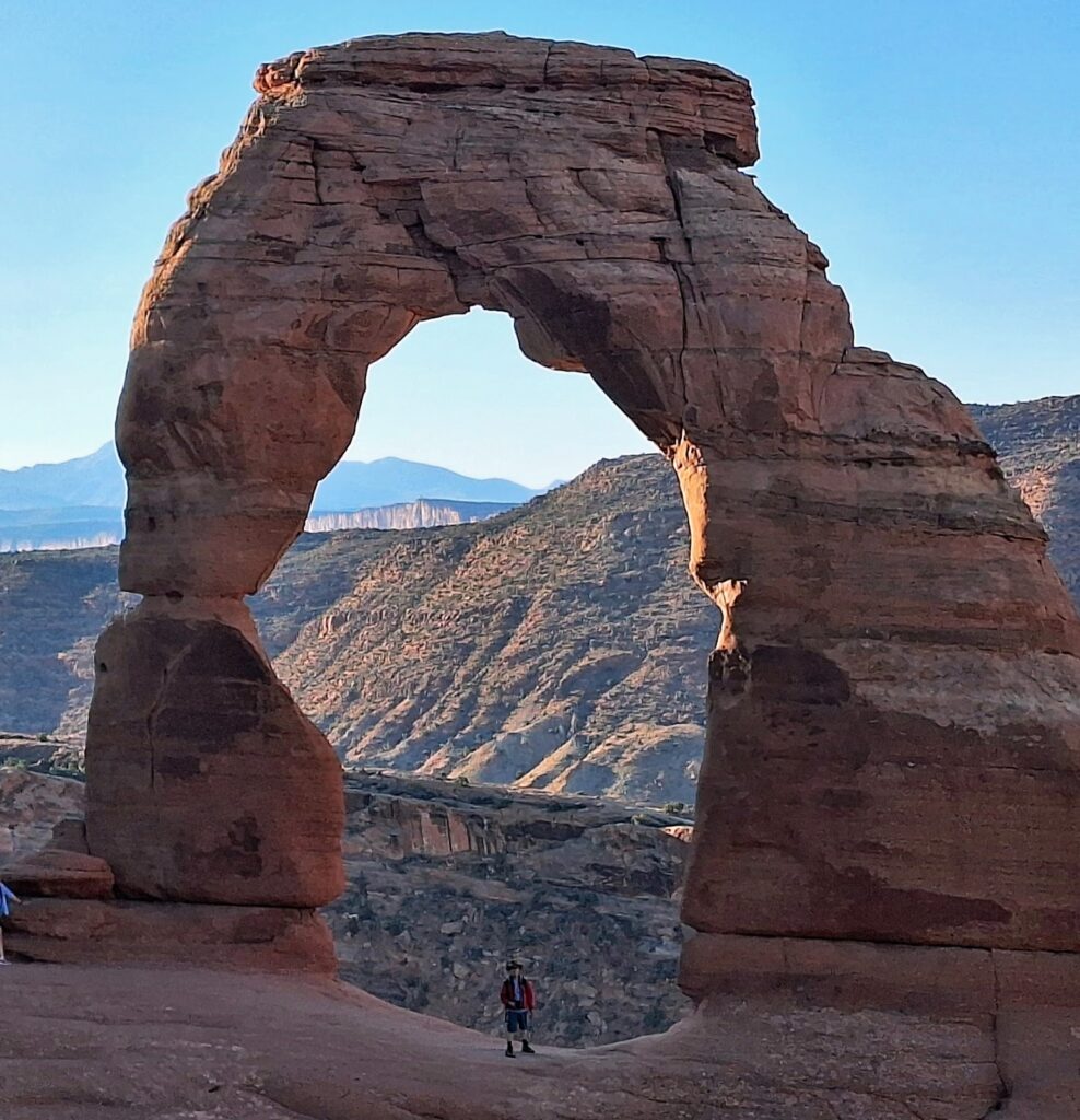
Today was a capstone day for our week in Moab. We returned to Arches National Park this morning (at 6:30 A.M.) to catch the morning sun on the Delicate Arch. Getting there required a 1.5 mile uphill hike on narrow and occasionally steep trails. I had no trouble letting the younger folks (and some who appeared older) pass us on the trail.
The top at the arch is not for those with Acrophobia. I don’t suffer from that condition, but paid close attention to where I put my feet (and hands when necessary).
Try as I might, I was unable to get the raven to talk. On the way down, we checked out some petroglyphs. I’m awaiting the NPS translation service to understand the message.
After achieving our sight seeing goals, we adjourned to jail for breakfast. It was so filling to be coma inducing.

Up early at 5:00 AM to get into Arches NP before 7:00 AM because no morning timed admission slots were available today. Our next five mornings will have early starts for various reasons. It will be nice to wake up in our bed and not need to get going first thing.
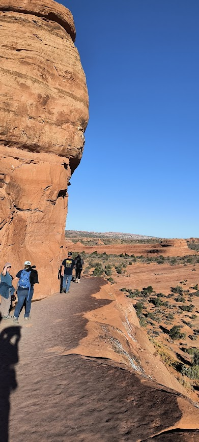
The line into Arches moved pretty quickly at 6:30 AM. I was pleased to see some of the cars in front of us pulling off to view areas or earlier parking lots than the Delicate Arch trailhead. We scored a spot convenient to the trailhead and started our march. Online research conducted last night warned us of occasional steep pitches and narrow trails. We probably stopped at least a dozen times to catch our breath. I had no trouble allowing the younger (or older) hikers to cruise by us. The two most unnerving sections of the trail were near the end (surprise). First was a section up a largely clear rockface (up hill mind you) with very few trail markers. Being on rock, I couldn’t rely on footprints to identify the trail. Fortunately there were plenty of the aforementioned faster hikers to follow (which only worked if they were in sight – it was still somewhat dark at this time). The image below provides more details on our route this morning.
More than once Cathy told me “This is hell”. I most definitely put her outside her comfort zone this morning. The second hard part wasn’t steep, but was quite narrow. It was just barely wide enough for two people to pass each other. Last night another guest at the resort mentioned someone traversing that section basically clinging to a sheer rock wall. Thankfully that section ended at the Delicate Arch viewing area.
I quickly realized this viewing area was quite narrow and bordered by steep ledges. No doubt the NPS deals with visitor falls from this vantage point. With some careful maneuvering I got myself under Delicate Arch so Cathy could take a picture of me wearing my travel hat and red wind breaker (below). By the time I returned to Cathy’s location, the trail endpoint was quite crowded.
We started downhill on the scary narrow section. Being a (mostly) downhill route we only needed to stop at a couple of switchbacks that were going uphill.
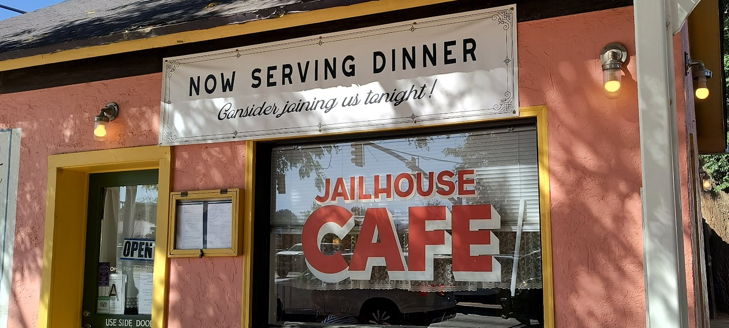
On the way down we decided to indulge at the resort’s breakfast buffet. I thought about bacon most of the way down. Alas, we arrived at the resort seven minutes after the restaurant closed its breakfast hours. The front desk clerk strongly recommended the Jailhouse Cafe for brunch. This building served multiple purposes since it was built in 1885 as a private residence. As the name implies, it was a jail for a time in the early 1900’s. The building went through several other purposes before transitioning to a different type of hospitality becoming the Jailhouse Cafe in 1992. We ate so much that moving wasn’t easy (possibly attributable to a week of hiking). After breakfast we indulged in some retail therapy on Moab’s Main Street, but didn’t make any purchases. We ended back at the resort close to noon.
The last full day at a holiday location is occasionally melancholy. We knew we needed to prepare for checkout (starting with laundry). Dinner was last night’s leftovers which pretty much emptied the refrigerator of food bought for our stay in Moab. The only downer today was the loss of WiFi. For some reason after a week of no problems, we were told that we needed to pay ($6.95 per day – not going to happen).
September 19, 2025 – Moab Utah
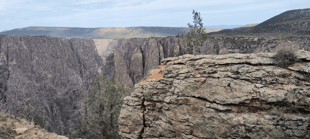
Today was a long (but enjoyable) day. Hence, only one picture from the Black Canyon of Gunnison National Park.
We stopped in Grand Junction at Fishers Liquor to pick up wine as a gift for Mark and Tara. While there, I snagged a walnut liquor. Hopefully it’s tasty. We stopped at a Wal-Mart to deconsess, pick up something to clear my head congestion and buy a replacement pair of sunglasses. The frame in my other pair cracked at some point yesterday.
The drive into Black Canyon of Gunnison National Park showed effects of the South Rim fire. This was one of three lightning caused fires starting at the park on July 10, 2025. The fire and subsequent damage prevented the South Rim portion of the park from reopening until August 28, 2025. They saved the Visitor Center and most other outbuildings. We only had a couple of hours to visit the viewpoints I curated for us. We noticed the scenic road appeared to have been repaved and restriped after the fire in the burn area. I was amazed the NPS was able to get that done in the days following the fire and before our arrival.
We drove into Salida this afternoon successfully navigating Monarch Pass. At 11, 312 feet above sea level, I’m confident this was our highest driving elevation for this trip. The road up and down the pass was not easy, with turns, steep parts, no shoulders, and (likely) fatal drop-offs. Our friends Mark and Tara graciously offered to host us in Salida for two nights. Shortly after we arrived, they took us to view the house they are having built in town. The lot is right next to the South Arkansas River. They are building the house as green and accessible as possible. The house is built using hempcrete making the exterior walls 12” wide. Between that and a solar array with two Tesla battery packs, I don’t expect their power bills will be too much. Mark and Tara expect to be in their new house by mid-December this year. We drove back to their current house, enjoyed a dinner of homemade chicken soup and turned in for the night.
September 20, 2025 – Salida Colorado
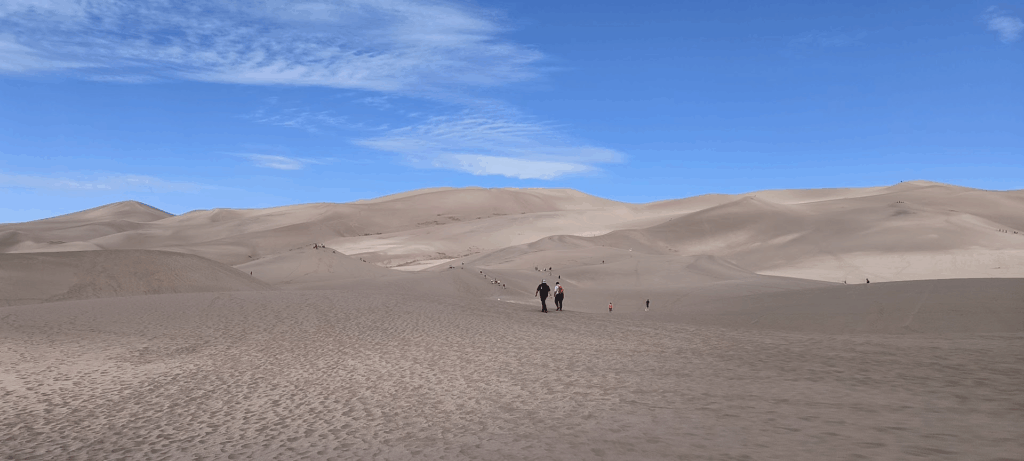
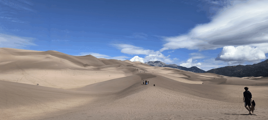
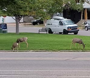
Today we started at Great Sand Dunes National Park. Somehow we made a wrong turn and ended up on “S” Mountain overlooking Salida (see the next picture for explanation).
After our day of walking around enjoying the scenery, we noticed this family of deer eating dinner across the street.
Tomorrow we start our journey home. This trip has been great. I’m looking forward to seeing the Richmond folks.
Breakfast was farm raised scrambled eggs with a variety of fresh vegetables sourced from Mark and Tara’s farm share membership.
After breakfast we drove (1.5 hours) to Great Sand Dunes National Park. For completely inappropriate reasons, I kept thinking it was the world’s largest litter box. Though no felines were seen, a number of visitors brought their canine companions. Walking what seemed like a mile across sand took a lot out of Cathy and me. We maybe got 100 feet of the 750 foot elevation before stopping. Some visitors brought boards and other things to slide down the dunes. None of them attempted any aerial maneuvers while we were there.
We drove back to Salida where we ate a late lunch at the Soul Craft Brewery. Tara then took us up to S Mountain (images above). Google Maps calls this feature Tenderfoot Hill. The “S” designation is due to the 100 foot “S” painted on the town side of the mountain. For that reason, Salida locals call it “S” Mountain. Reinforcing the naming, the trail we walked up is named “S Mountain trail” (also per Google Maps) Cathy and I most definitely got our steps in today (at a decent elevation no less). The trail head went up more than a quarter of S Mountain meaning we walked around S Mountain more than four times going up (and then again on the way down). We must have stopped three or four times to catch our breath on the way up.
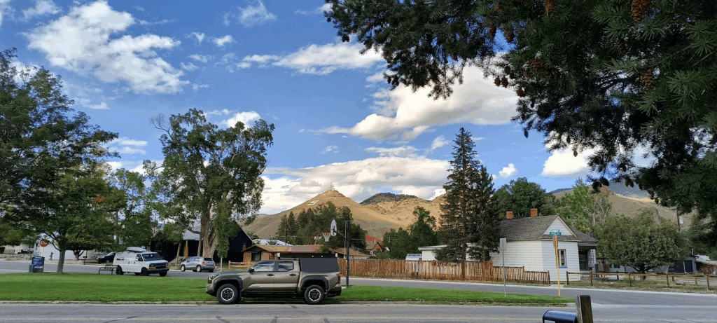
The historic district of Salida is good sized for a population of around 6,000. It’s well maintained and apparently enjoys a Winter and Summer tourist season. Once more we squeezed into the shoulder season.
Dinner was roasted peppers and a variety of Hispanic themed dishes at Beth and Tony’s house. Mark and Tara have an enviable set of friends. I’ve seen Tara do this in Richmond and in Washington DC where she lived before Salida.
September 21, 2025 – Salida Colorado
Up early for a long drive to Perry Kansas to visit and stay with Cathy’s cousin Janet and her husband Bob. On top of a 9+ hour drive, we lost an hour going back east to the Central Time Zone. We’ve been in Mountain Standard Time for over two weeks. The drive east out of Salida was through mountain canyons mostly following the Arkansas River. We passed multiple signs warning about rock scraping work. Apparently that is done in this part of the state to prevent rocks falling off cliff faces onto highways.
Once we exited the mountains we still had quite a bit of driving to get past Colorado Springs. By the time we finally got on to I-70, we had been driving for over three hours. We now faced over 400 miles (no kidding) of I-70 on flat plains as boring as you would expect. Unlike the Dakotas and Montana, we couldn’t legally drive 80 MPH making the drive that much longer. Fortunately we didn’t encounter heavy traffic or construction. Even so, we didn’t pull into the Tust’s driveway in Perry Kansas until after 6:30 PM.
Janet and Bob graciously delayed their dinner. They followed a tour of their 1890 house (built by the banker for whom Perry is named) with time on their patio around the fire pit. Only after dinner and while we were finishing the home made pie for dessert did I set my watch for CST. Janet and Bob still work and Bob starts his day at 3:30 AM. We concluded our evening enjoying the quiet neighborhood. In many respects this evening was a nice transition for our trip home. We spent time with family and waking up in a house (albeit someone else’s). Our being early risers made it easy to get on the road. I told Janet the train whistle (rail crossing two blocks from their house) reminded me of home.
September 22, 2025 – Perry Kansas
Today was mostly about getting to our hotel in New Albany Indiana. Doing so required driving across Missouri and Illinois (and a decent chunk of Indiana). We got to experience yet again Indiana’s never ending highway construction. This was our third road trip through Indiana this year and everyone one of them was impacted by road construction. It would be one thing if it was on the same stretch of road. Alas, it appears Indiana’s DOT has an immense budget for highway construction ensuring anyone passing through any part of the state experiences road construction. For likely obvious reasons, many of our thoughts at the hotel were about looking forward to getting into our own house the next day.
September 23, 2025 – New Albany Indiana driving home to RVA
Leaves turning in western Virginia. Falling leaves blowing across highways in West Virginia illustrated changing seasons. We travelled through this part of the country before it reached peak colors, but our time in Colorado showed aspen leaves turning golden. We saw the descent of colors over the three days we were in that state.
Having attained my 50th state is a memorable accomplishment. Below are a few numbers from our trip out west:
- 7,000 miles driven
- 17 states visited (VA, WV, OH, IN, IL, WI, MN, ND, SD, WY, MT, ID, UT, CO, KS, MO, KY)
- 20 nights on the road
- Lodging at 7 hotels, 2 time shares, 1 cousin, 1 friend
- 11 national parks or monuments
- 2 state parks
- Countless roadside attractions
We had a great time seeing family and friends. While the parks we visited were memorable, some of the quirky roadside attractions we passed were just as interesting. I’m pleased to report we made it back home without any significant issues. The chief downside of ending our trip was needing to transition back to real life the very next day. Even so, it is great to reconnect with our RVA family and friends. Thank you all for reading this blog. Don’t be surprised if I make additions or other changes over time.